
Need Help? Let's Talk
+977 985-1095800


10% OFF

Trip Duration 05 Days
Group Size 2-10 People
Maximum Altitude Gosaikunda Lake (4460m/14632ft)
Difficulty Grade Moderate to Difficult
Start & End Point Kathmandu/Kathmandu
Best Seasons Mar-Jun, Nov-Dec
Small Group Departure Dates for 2026 and 2027
Note: We can run a trip for solo travelers, couples, friends, and family with children. Our private trips run daily. For small group travel, please check the dates below. If the dates below do not suit you, please email us or WhatsApp us at +9779851095800 to travel on your preferred dates.
September: 05,10,18,22,30
October: 02,05,08,12,16,20,24,30
November: 04,07,11,14,17,21,25,30
December: 03,07,12,17,21,24,30
Janurary: 02,12,20
February: 08
March: 03,07,11,14,17,21,25,29
April: 02,06,10,13,16,19,22,28
May: 02,07,11,15,20,28
June: 05,10,15,20
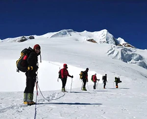
Highlights of Gosaikunda trek
- See the worshiped Gosaikunda Lake located beneath the peak tops in snow.
- Opportunity to watch an incredible sunrise while facing the Langtang Himalayan peaks.
- Encounter the religious ambiance that dwells in the pilgrimage locations of Hindu and Buddhist traditions.
- Trek past rhododendron forest landscapes, alpine meadows, and a mix of rocky surfaces.
- Travel over Laurebina Pass with its astonishing elevation of 4,610 meters.
- Discover Tamang villages alongside Sherpa communities to understand their cultural ways of life.
- See Dhami-Jhankri shamans conducting their rituals while attending the Janai Purnima festival.
- See Himalayan thar, red pandas, together with numerous bird species and the Himalayan thar among others.
- Relaxing in tea houses, which provide welcoming hospitality and traditional Nepali food while offering relaxation opportunities.
- Enjoy unobstructed views toward Langtang Lirung, Ganesh Himal, and Manaslu ranges
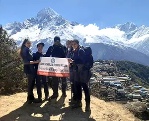
Overview of Gosaikunda Trek
Starting on the Gosaikunda Trek, visitors can experience the holy Gosaikunda Lake, located 4,380 meters inside Langtang National Park. Along the trail you will find amazing sights of the Langtang Himalayan range and the views of Ganesh Himal and Manaslu while moving through wooded forests, agricultural territories and local settlements.
Thousands of Hindu and Buddhist pilgrims come to Gosaikunda Lake every August for the Janai Purnima festival because the location has religious importance for both faiths.
Beginning at Dhunche through stunning transportation from Kathmandu you will progress through oak and rhododendron forests towards the destination.
On your adventure, you will encounter two points, the significant Buddhist religious site Sing Gompa and the welcoming local settlements. When visiting Gosaikunda Lake, you will find its spiritual feel coupled with its sparkling lake water.
Novice and knowledgeable travelers can pursue the Gosaikunda Trek successfully. The trek remains short even though altitude adjustment plays a crucial role in achieving successful completion since the high elevation presents a challenge to most climbers.
Travelers should visit Nepal to explore the fascinating cultural sites and remarkable landscapes and holy attractions of the Gosaikunda Trek.
Gosaikunda Pilgrimage Trek
During the Gosaikunda Trek, religious pilgrims visit the holy lakes of Gosaikunda which hold significant value in the Hindu faith. Local myth tells that Lord Shiva poured water to form this lake. Gosaikunda stands as the main holy lake while it shares its area with Saraswati Kunda as well as Bhairab Kunda and Surya Kunda.
Water from Gosaikunda stream flows toward the Kumbheshwar Temple situated in Patan which lies 60 km southwest of Kathmandu.
The Janai Purnima celebration brings Hindu devotees to conduct both the recitation of the Gayatri Mantra and the change of their Janai sacred thread in symbolic purification rites. As part of the ritual priests use red-yellow sacred thread (Rakshya Bandhan) to tie protective wrist bands around the devotees.
The sacred image of Lord Shiva located in the heart of Gosaikunda represents the divine nature of the lake. Each year large numbers of devotees journey to this sacred destination more frequently during the major festival month of August. The community members walk to the lake but traditional pilgrims complete their sacred bathing ritual in the freezing water.
Gosaikunda receives more than 6,000 yearly visitors to the religious site based on festival management reports. Young adventurers roam the area yet middle-aged and elderly pilgrims concentrate on religious rituals.
Altitude sickness prevention remedies include using lemons for sniffing and consuming garlic as well as applying cornflour to the skin.
Langtang Valley with Gosaikunda Lake Trekking Video
Itinerary of Gosaikunda Trek
DAY
01
01
Day 01: Kathmandu Drive to Dhunche
Beginning from Kathmandu, the adventure leads travelers to Dhunche which exists at 2,030 meters above sea level. During the approximately 7-hour travel visitors pass through enchanting scenery that shows them the traditional village life alongside terraced agricultural fields.
Dhunche stands as the main town of Rasuwa district while it also functions as the main entrance to visit Langtang National Park. Trekkers arriving first stop at the local bazaar and have opportunities to meet the Tamang community before organizing their upcoming trek.
Bus
6-7 hrs
Accommodation
Guesthouse
Meals
Breakfast, Lunch, Dinner
Altitude
Dhunche (2,030m)
DAY
02
02
Day 02: Dhunche to Sing Gompa
The first 5 to 6-hour hike begins at Dhunche to lead trekkers to Sing Gompa located at 3,250 meters and popularly known as Chandanbari. During the spring season the forest trail becomes beautiful with numerous blooming rhododendron and pine and oak species.
Trekkers who traverse this route may spot langur monkeys together with many different bird varieties. The ancient temple of Sing Gompa in the elevation of 3,250 meters features a Buddhist monastery as well as picturesque vistas towards the Langtang Himalayas.
The village keeps its status as famous through its yak cheese factory operation which allows people to try and acquire handmade local cheese.
Walking Day
3-4 hrs
Accommodation
Teahouse
Meals
Breakfast, Lunch, Dinner
Altitude
Sing Gompa (3,330m)
DAY
03
03
Day 03: Sing Gompa to Gosaikunda Lake
On day three, travelers need to spend 6 to 7 hours trekking up to the sacred Gosaikunda Lake, which rests at 4,380 meters. The trail moves vertically uphill while taking hikers through alpine zones where they can admire views of Langtang Lirung and Ganesh Himal peaks.
Travellers walking towards Gosaikunda will find more than one pristine lake that holds religious importance for the group.
Gosaikunda functions as a spiritual destination visited by practitioners from both Hindu and Buddhist faiths because they believe Lord Shiva made the lake. Clear natural waters of Gosaikunda flow peacefully among mountainous terrain to create a serene exploration area.
Walking Day
4-5 hrs
Accommodation
Teahouse
Meals
Breakfast, Lunch, Dinner
Altitude
Gosaikunda Lake (4,460m)
DAY
04
04
Day 04: Trek from Gosaikunda all the way down to Dhunche
Enjoy your breakfast at the highest lake before heading down to Dhunche. This is on the last day of our trek on foot. Our Gosaikundatrek trails descend all the way to Sing Gompa.
We first passed Lauribanayak, with magnificent mountain views and forests. Stop lunch at Singompa and have some rest.
The trails descend through pine, silver oak, and rhododendron forests. You can also see marijuana plants across the suspension bridge over the Sing Gompa Stream.
Now, the path stretches flat. Here, there is a mountain Mineral water factory and some human settlements. Overnight at Dhunche, the district headquarters of Rasuwa district.
Walking Day
6 hrs
Accommodation
Guesthouse
Meals
Breakfast, Lunch, Dinner
Altitude
Dhunche (2,030m)
DAY
05
05
Day 05: Dhunche Drive to Kathmandu
A trip from Gosaikunda back to Kathmandu signifies the conclusion of the Gosaikunda trek during the last day. At the end of the trekking adventure people remember stunning views along with meetings with the local population and the calm presence of Gosaikunda Lake.
The 5-day Gosaikunda Trek presents trekkers with both adventurous exercises and cultural and religious insights that create this wonderful trekking experience in Nepal’s heritage zones.
Bus
6-7 hrs
Meals
Breakfast & Lunch
Altitude
Kathmandu (1,400m)
Trip Extension
Suppose you have more time in Nepal after this trip. In that case, we can help you to extend your trip by running different treks in Nepal, tours in Bhutan and Tibet, Jungle safari tours at Chitwan, Bardia, and other National parks, Nepal luxury hotel booking, Rafting, Ultra-light flights, or any other travel-related services. You can get more information here.
Includes/Excludes
What's Included?
- A trekking guide certified and licensed by the government has training in high-altitude sickness and first aid.
- Local trekking porter for the trek, one porter for two trekkers basis.
- Trekking staff, food, accommodation, salary, equipment, insurance, and clothing.
- Local Tea houses, also called guest houses/ lodges, twin sharing during your journey.
- You can choose your daily meals (breakfast, lunch, and dinner) from the menu, which includes different types of food.
- Langtang National Park Trekking Permit.
- TIMS Card for the Gosaikunda Trek.
- Group medical supplies (Guide will carry essential medicines).
- Above the Himalayan duffel bag. ( If you need to, please let us know before you book the trip and remind us in our pre-meeting at our office)
- Kathmandu to Dhunche transfer by Local bus ( private land cruisers are also available by adding separate cost)
- Dhunche to Kathmandu transport by Local bus ( private land cruisers are also available by adding a separate charge)
- Comprehensive pre-departure information and trip dossiers
- Above the Himalayan Gifts and Trekking certificate after finishing your trek.
- All necessary papers work, office Service charges, and all Government Taxes
What's Excluded?
- Any service in Kathmandu.
- Alcoholic, hot ( tea & coffee), cold drinks, mineral water, and hot water.
- Personal expenses include laundry, telephone calls, snacks, dessert, beverages, bar bills, and battery charging.
- Travel Insurance should include emergency evacuation coverage while trekking.
- Tips for tour/ trekking staff and driver.
Route Map & Altitude Chart
Who can do the Gosaikunda Trek 5 days?
The 5-day Gosaikunda Trek provides adventurous trekkers with excellent fitness and an opportunity to discover the Langtang region’s beauty during a quick trip. The trek suits novice participants yet previous hiking experience at elevated altitudes makes it easier to succeed.
The elevation reaching 4,380 meters requires appropriate acclimatization as well as controlled movement from trekkers to avoid altitude sickness symptoms.
Travelers who need a compact Himalayan escape should choose this trek as their perfect option. The entire trek can be finished within five days by those who have good physical stamina and strong climbing abilities. Traveling to view Gosaikunda Lake requires average trekking ability to complete daily paths of 5 to 7 hours over forested, village, and rough terrain.
The site proves highly appealing to Hindu and Buddhist religious followers who make a pilgrimage to Gosaikunda Lake. This trek gives great value for trekkers who want to see natural landscapes and observe mountains while experiencing local cultures. All solo and group, and guided travelers should choose the 5-day Gosaikunda Trek as a demanding yet fulfilling adventure.
Best Seasons for the Gosaikunda Trek
Visitors should schedule their trek to Gosaikunda for spring (March to May) or autumn (September to November) because these seasons provide excellent weather visibility together with stable climatic conditions.
The region sees winter snow during cold months, followed by monsoon which produces excessive moisture that makes walking conditions dangerous.
Spring (March to May)
From an aesthetic and climatic standpoint, Spring turns out to be the ideal period to undertake the Gosaikunda Trek. Spring provides perfect conditions for trekking because the area experiences balanced weather and pleasant temperatures, together with the clear blue sky.
Scarlet rhododendrons as well as magnolias and wildflowers, decorate the trails during this period, creating a stunning environment. All three mountain,s including Langtang Lirung, Ganesh Himal, along Manaslu, appear spectacular.
Spring in this region brings temperatures between 10°C to 20°C at lower altitudes and between -5°C to 5°C at Gosaikunda. The climate during this period produces superb conditions for trekking because it brings wonderful sights alongside exciting cultural discoveries.
Due to its popularity, you will encounter an average number of people during this time period on the hiking trail.
Autumn (September to November)
Autumn forms a perfect time frame to undertake the Gosaikunda Trek because it provides stable meteorological conditions in combination with clear atmospheric conditions.
The new air after monsoon provides an exceptional experience because mountains stand out in full clarity. The climate during this season becomes gentle with lower areas averaging 10°C to 18°C while the Gosaikunda region maintains temperatures between -5°C to 5°C.
During August and early September, Janai Purnima attracts substantial Hindu and Buddhist adherents to the festivities. Regional climate during autumn remains dry so trekking becomes highly suitable.
The hiking trails receive many visitors yet remain non-crowded, while the forests continue to display their jungly appearance. This season offers some of the best photography opportunities, with crystal-clear views of the Himalayas.
Winter (December to February)
Chilly winter weather conditions and snowfall create an attractive but tough experience during the Gosaikunda trek. The frozen condition of the lake creates an enchanting sight.
At daytime, the region experiences a temperature range between -5°C to 10°C, but evenings bring temperatures that drop down to -10°C or lower in elevated areas.
Winter trekking suits people who already have trekking experience and appropriate equipment for dealing with both severe low temperatures. The paths are generally empty which creates a serene distant adventure.
The Laurebina La pass becomes impossible to cross when significant amounts of snowfall entirely close the route. Because of seasonal closures the tea houses are unavailable while trekkers need to plan thoroughly to handle the extreme conditions.
Monsoon (June to August)
During monsoon season big rains transform the Gosaikunda Trek paths into risky conditions because of their dangerous slipperiness and the spread of leeches and confusing visibility. High humidity causes ongoing path obstructions by landslides that mainly impact the trail between Dhunche and Sing Gompa.
The trek maintains its attractiveness through its colorful waterfalls and abundant green growth despite weather difficulties. Thousands of pilgrims come to celebrate the Gosaikunda Festival in August, which brings a vibrant environment to the place.
During the monsoon the necessary requirements for trekking include waterproof gear coupled with effective planning and adaptable decision-making. Fewer people go trekking during the off-season, resulting in affordable room rates throughout the trail.
Gosaikunda Lake Significance
Gosaikunda Lake maintains great spiritual importance for Hindus together with Buddhist religious followers. Lord Shiva has chosen this sacred place situated at 4,380 meters inside Langtang National Park as his home.
The Hindu belief states that Lord Shiva formed Gosaikunda by using his trident to dig into the mountain as he sought to relieve his thirst after consuming poison during the ocean churning ceremony. Because of its creation myth the lake attributes holy and purifying properties to its water.
Gosaikunda welcomes thousands of devotees every year ,with Janai Purnima festival being the major pilgrimage period in August. Many devoted followers choose to bathe at the lake because they believe it eliminates their bad deeds and delivers divine gifts.
Hindu men take the opportunity of Janai Purnima to replace their sacred thread (Janai). The site holds religious value for Buddhist practitioners because they view the location as a holy space for meditation.
Despite its sacred religious value, Gosaikunda presents itself as a magnificent natural attraction that stands in the breathtaking union of stunning mountain peaks and peaceful surroundings. Gosaikunda lake shows its clear water surface up to the sky, enhancing the stunning vista.
The lake keeps its frozen state during the inter months, thereby boosting its captivating charm. People visit Gosaikunda Lake to achieve spiritual growth and investigate the region’s natural wonders, which combine worship with outdoor experience.
Gosaikunda Trek Difficulty
The Gosaikunda Trek presents moderate hurdles that include difficult terrain along with extreme heights and unsteady meteorological conditions. The 1,960-meter town of Dhunche starts the trek, which grows to reach Gosaikunda Lake at 4,380 meters during a few days of climbing,g thus causing significant risk of altitude sickness.
Breathing problems alongside headaches and exhaustion emerge when people travel to high elevations because of poor oxygen levels, so visitors need to adjust to the altitude.
The trekking path includes challenging elevations combined with rocky terrain and forested areas, which demands stamina and strong endurance from participants. The path between Sing Gompa and Lauribina requires a lengthy, steep elevation of massive height.
The challenging aspect of the Laurebina La Pass at 4,610 meters emerges from its high altitude which brings extreme weather conditions as well as hazardous icy terrain.
Weather conditions also affect difficulty. During the winter months, from December to February, the trails become hazardous due to heavy accumulation of snow. The June to August monsoon season creates uneven terrain paths, which become hazardous because of leeches.
During the spring and autumn seasons, between March to May and September to November, the weather remains steady while the paths stay visible.
A proper amount of preparation enables beginner trekkers to finish this trail, but experienced hikers will find it more suitable. Keeping moving at a controlled speed combined with hydration will minimize physical fatigue and escape altitude dangers.
Physical Fitness Requirement
Physical exertion at a moderate to good level is needed to undertake the Gosaikunda Trek because it includes demanding slopes and extended marches, and elevated terrain. Hikers must perform daily treks of five to seven hours duration on challenging terrain which features steep mountain climbs.
Trekking from Sing Gompa to Lauribina represents the most strenuous part, as trekkers need exceptional stamina and endurance because of its steep terrain.
The elevation of Gosaikunda at 4,380 meters creates a high possibility of developing altitude sickness symptoms, including dizziness as well as headaches and fatigue. The combination of proper acclimatization and hydration procedures reduces these possible dangers.
The preliminary training for Gosaikunda Trek begins with cardio workouts involving running, cycling and swimming that need to start 2 to 3 months before the actual trek date.
Leg and core strength training enables better endurance during hikes, which involve uneven surfaces. Going on short backpack hikes imitates the demanding environment that trekking presents. The practice of yoga as a flexibility exercise helps prevent walking-related muscle strain.
The path at high altitudes requires strong mental fortitude thanks to its rigorous nature. Through maintaining a positive attitude along with remaining patient and determined, anyone can survive the fatigue that builds up on the trek.
Travelers who want to begin the trek need to exercise before attempting it yet medical consultations should occur for anyone dealing with heart-related or respiratory problems. Following a smooth pace and drinking enough fluids, and scheduling regular rest stops together provide conditions for a pleasurable trekking experience.
Essential Permits for Gosaikunda Trek
For the Gosaikunda Trek, trekkers must obtain both the Langtang National Park Entry Permit and the TIMS (Trekkers’ Information Management System) Card. The two essential permits provide both environmental protection and trekker safety for Gosaikunda Park.
Foreign travelers must pay NPR 3,000 or $23 for the Langtang National Park Entry Permit, whereas Nepali citizens spend NPR 10,0 and SAARC nationals spend NPR 1,500.
The permit directly supports conservation as well as the development initiatives operating in the Langtang region. The entry permits for both the Nepal Tourism Board office in Kathmandu and the checkpoint in Dhunche offer locations to obtain them.
All trekking individuals must possess a required TIMS Card entry. An individual trekker must pay $20, while group members need to pay $10 per person for their entry permits.
People can purchase this permit at Nepal Tourism Board locations in addition to authorized trekking agencies. Official tracking of trekkers becomes possible through the use of the TIMS Card, which functions in emergency situations.
An added requirement for crossing the Gosaikunda Pass leads you to obtain special permits to enter both Helambu and Shivapuri National Park. Before entering each checkpoint you must present your permits because authorities will check them. You must obtain permits prior to your trek start since failing to show permits leads to financial penalties.
Accommodation and Meals during the Gosaikunda Trek
During the Gosaikunda Trek, all lodging options are limited to simple teahouses and accommodations. Each lodge supplies basic accommodations featuring two beds as well as blankets together with communal bathroom facilities.
The quality of facilities deteriorates as you climb higher, while hot shower services are available only at an extra cost. Attaining early reservation or booking ahead will secure accommodation space during busy holiday seasons in the trek.
Nepali traditional cuisine forms the basis of all meals served on the trail. Dal Bhat comprises three elements including rice, lentil soup together with vegetables to create a balanced diet with sufficient energy and nutrition.
People who visit can obtain meals from noodles to pasta as well as soups alongside Tibetan bread. The breakfast menu features porridge together with pancakes as well as eggs. Higher altitudes decrease food selection and increase costs because of the obstacles of transporting supplies into this altitude zone.
Teahouses serve their customers with tea, coffee and hot lemon beverages, but they charge high prices for water in bottles. The standard equipment for trekkers includes water purification tablets, which enable them to obtain clean water from natural water sources.
The consumption of alcohol should be strictly avoided at heights since it intensifies dehydration and heightens the risk of developing altitude sickness. A basic accommodation and dining experience in the Himalayas creates a warm, welcoming ambience inside the region.
Availability of Drinking Water
Water sources exist throughout the Gosaikunda Trek, yet travelers must clean their drinking water because it cannot be consumed as is. Drinking water prices rise in relation to altitude because of transportation expenses at local teahouses.
Drinking water bottlers charge NPR 50 at lower heights but hike their prices to NPR 200 and above near Gosaikunda. Using a reusable bottle together with water purification procedures will help both minimize expenses and decrease plastic waste.
Natural water sources from streams as well as rivers and village taps deliver fresh water although they could hide bacterial contaminants or pollutants. Drinking purified water obtained through tablets, filters and UV purifiers remains safe for consumption. Visitors can access boiled water at tea houses at a minor cost as one of the dependable water sources.
Hydration stands as an essential requirement when ascending high elevations because it helps shield individuals from developing altitude sickness. All trekkers need to consume at least 3 liters of water during each day.
The consumption of both alcohol and too much caffeine proves helpful for maintaining proper hydration. Trekkers should choose their water purification techniques prior to starting their trek because access to clean drinking water directly determines the success of the expedition.
Wildlife and Plants
During the Gosaikunda Trek, travelers pass through Langtang National Park where they can spot both various wildlife species and different types of vegetation.
From the base until the lower areas, the landscape comprises thick forests including rhododendron, oak and pine trees, which generate wonderful natural freshness. Rhododendron trees display their spectacular red, pink, and white blooms across the hillsides, which occur during spring.
Rising into higher altitudes reveals a transition from forested areas to mountain pastures and stone terrain. The mountain flora consists of juniper alongside dwarf rhododendrons found within these particular areas. Two important medicinal herbs found in higher elevations include yarsagumba and jatamansi whose traditional medicinal value is highly recognized.
The local wildlife population consists of Himalayan black bears alongside red pandas and along with the presence of both langurs and Himalayan tahr. Hikers have the chance to witness musk deer feeding within forested areas, and in rare chances, even the snow leopards.
Higher areas of this region house Nepal’s national bird Danphe (Himalayan monal), besides many other bird species. Visitors to the area are expected to protect nature by staying away from wildlife and to maintain cleanliness around all trails.
Altitude Sickness and Prevention during Gosaikunda Trek
Fitness challenges from altitude sickness frequently trouble travelers on the Gosaikunda Trek because the trail exceeds 4,380 meters. Patients who experience altitude sickness display headache symptoms together along with dizziness with nausea, and difficulty breathing.
Inadequate attention to symptoms can result in two dangerous medical conditions known as high-altitude pulmonary edema (HAPE) and cerebral edema (HACE).
Trekkers should optimize their height ascension process by climbing slowly because this strategy allows their bodies to adapt naturally. Water intake together with alcohol reduction alongside controlled walking speeds reduces altitude sickness risk.
Acclimatization is the primary solution to reduce altitude illness risk which lies in high-altitude exposures. People who take Diamox (Acetazolamide) for acclimatization need medical approval before using the medication.
The proper action when facing altitude sickness symptoms involves going to a lower elevation immediately. Progression of the trek should be halted when symptoms arise as it poses life-threatening risks.
A combination of local teahouse operators and guides possesses knowledge about altitude sickness, which allows them to provide appropriate support in case assistance is required. The combination of appropriate planning and knowledge leads to secure and delightful trekking adventures.
Gosaikunda Trek Cost
The total expenses for the Gosaikunda Trek span between $500 and $800 with different factors determining the overall cost. Adding the Langtang Valley Trek or Gosaikunda Pass crossing to the trip routine will affect the total expense. The price depends on how many people are in your group as well as the rental costs and the expenses you choose to cover yourself.
The average estimated expenses for Nepali hikers during Gosaikunda Trek amount to NPR 4,000 for daily food and lodging. The bus fare to enter Dhunche, which stands as the trek beginning point, amounts to NPR 1,000 to 1,200 each way. Private jeep rentals exist, although they charge a higher price than other options.
Every person makes different choices when it comes to spending personal money. In Dhunche, visitors can find small shops and local bars as relaxation spots with their friends. Consuming alcohol should be avoided when located at high-altitude regions.
The final expense of Gosaikunda Trek originates from group dynamics as well as the selection of services and the manner in which participants allocate their budget.
What to pack for Gosaikunda Trek
Gosaikunda Trek requires multilayer clothing since it climbs through unexpected weather conditions at high elevations. Your combination of down jacket, fleece layers, and water-resistant base layers will provide proper warmth to your body. Travelers benefit from using a jacket that ensures both rain and wind protection , particularly above higher elevations.
Sturdy trekking boots offering solid ankle support become crucial because of the rugged terrain conditions. Trekking poles offer two main benefits in steep terrain by providing support against knee injuries on the way up and down.
The 30 to 40 Liter backpack functions as your portable base for carrying essential items involving food, water, medical tools and lightweight night illumination.
Protective coverings consisting of gloves and a beanie, together with sunglasses,s shield you from chilly temperatures and strong sunlight. Sunscreen together with lip balm protects against sunburns since ultraviolet rays become more intense at higher elevations.
When staying overnight in teahouses a subzero temperature rated sleeping bag will provide necessary warmth. Water purification tablets together with a filter system provide proper access to safe drinking water.
One can enhance their comfort during a trek by including personal necessities, including toiletries and wet wipe,s and additional socks. A power bank maintains device power supply because the electrical power might be scarce in certain locations.
Operating with an efficient packing method reduces weariness and enhances movement in the trek. The trekking adventure becomes more comfortable when all preparations are completed prior to starting the adventure, while preventing avoidable physical challenges during trail time.
History and Culture of Gosaikunda
Religious and cultural importance attracts both Hindu and Buddhist followers to Gosaikunda. Hindu mythology recounts that Lord Shiva formed the lake through his Trishul (trident) strike on the ground after consuming poison needed a drink. Devotees accept that the holy water of this lake attracts thousands of pilgrims on Janai Purnima before and after August.
Gosaikunda maintains religious importance to Buddhists because they link it to the place where Guru Rinpoche conducted meditation. Religion in the Tibetan tradition strongly affects the way of life in Tamang and Sherpa villages through which the trek route leads.
The path to the site is marked by temples and religious symbols like prayer flags and chortens, which illustrate the historical Buddhist religious practices.
There are frequent religious rituals observed by local shamans (Dhami-Jhankri) who consider the lake home to divine power during pilgrim and trekking movements.
The local population of Gosaikunda comes to find spiritual blessings and wellness. Because of the combination between Hinduism and Buddhism, this cultural area stands out as a special site.
Travelers visiting this region must follow local customs by choosing simple clothing while paying attention to holy sites. Trekkers experience greater fulfillment when they meet local populations to understand their practices and join traditional celebrations.
Because of its spiritual aura and natural scenery, the Gosaikunda trek provides its participants with something beyond physical exploration.
Festivals in Gosaikunda Lake Trek
Both Hindu and Buddhist religious communities gather during the Gosaikunda Festival which occurs on the full moon day of August. Notable among the many devotees who visit Gosaikunda Lake are followers who come to worship Lord Shiva and perform their sacred water rituals.
The highlight of the performance is the Shamans team (Dhami-Jhakri) who conduct holy prayers and perform spiritual dances.
Water from Gosaikunda Lake continues to flow toward Kumbeshwar Temple which rests 60 kilometers southwest of Kathmandu. At this festival Hindu males conduct the Gayatri Mantra recitation and perform sacred thread changing rituals (Janai) through purification ceremonies.
Religious priests at the temple protect followers by placing a sacred red-yellow thread (Rakshya Bandhan) around their wrists. The spiritual powers of the lake are emphasized by an image of Lord Shiva that stands at its center.
Tourists who visit this destination can observe Shaman dances as they tour Laurebina La Pass through Surya Peak and the sacred sites of Ganesh Kunda and Surya Kunda. Different accommodations in the form of tea houses or lodges serve travelers throughout the trek.
In winter months when the lake turns into ice the local residents seek refuge at lower altitude settlements because of the harsh cold temperatures. Due to pilgrim availability, temporary shelters combined with camps provide facilities to visitors who brave the severe weather to perform their rituals.
Travel Insurance for Gosaikunda Trek
Gosaikunda Trek demands travel insurance because the altitude reaches severe heights where possible dangers exist. Tourists must be cautious about altitude sickness because the trek extends beyond 4,300 meters in elevation.
An appropriate insurance policy must provide medical emergency coverage together with high-altitude sickness treatment facilities and emergency helicopter transportation when required.
Travel insurance becomes beneficial due to unexpected weather conditions that trigger trip postponements or service suspensions. The insurance plan needs to include protection for disrupted flights as well as lost items and accidental incidents.
The high cost of emergency helicopter evacuations becomes bearable when a person obtains travel insurance because it protects from financial hardship.
When selecting insurance a person should look specifically for policies that include coverage for treks above 5,000 meters. People engaged in high-altitude trekking need to verify their travel insurance coverage because basic plans often deny this activity.
A person needs to keep their insurance policy document material and their emergency contact list nearby to get help without any delay.
A provision in travel insurance policy covers unexpected occurrences like damages or stolen possessions. Travelers who have experienced treks in the past must recognize that altitude sickness along with accidents pose significant dangers.
Travel insurance yields both relaxation and security benefits, which enable trekkers to savor their Gosaikunda Trek without worry.
Most Asked Questions by Travellers
Both autumn (September to November) and spring (March to May) represent the prime times for visiting Gosaikunda Trek. Spring and autumn provide excellent viewing conditions through their clear skies and moderate temperature levels.
Two permits will be essential for your trip, Langtang National Park Entry Permit costs NPR 3,000 or NPR 1,500 for foreign or SAARC nationals respectively and a TIMS card has separate fees of NPR 2,000 for solo trekkers or NPR 1,000 for group members. The permits can be acquired in Kathmandu city.
The Gosaikunda Trek features moderate to demanding obstacles because it contains tough inclines on uneven terrain above a maximum elevation of 4,380m. A proper preparation enables beginners to finish the trail while the trekking experience gives added advantages during the trek.
Yes, teahouses along the route offer basic rooms and meals like dal bhat, noodles, and porridge. The higher altitude leads to higher prices while hot shower services along with charging services often require additional payments.
The trail quickly elevates to high altitude parts during its progression. Proper acclimatization combined with hydration and avoidance of alcohol will help prevent getting sick at high altitudes. The development of any headache together with dizziness requires immediate medical attention.
The necessary items for trekking are sleeping bags together with warm layers along with trekking poles and good boots, water bottle, sunscreen and medical supplies basic for minimum needs.
Reviews on Gosaikunda Trek
Posted onVerified Thank you for the best tour we have ever had! I planned to stay at the Everest View Hotel this time and travel there because I wanted to see Everest, the highest mountain in the world, slowly, but despite the short schedule due to my children's school, all I got was a response that it was difficult to contact several tour companies. The Himaraya Trekking, Above, has worked out a smooth and safe schedule and had the best experience for me and my family. I will never forget the view of Mount Everest. Thank you very much.Posted onVerified Another Amazing Trip with Above the Himalaya This is my 3rd trip with Above the Himalaya and Puru. Each trip with Puru has exceeded expectation with the quality of the guides, porters and attention to detail. We were a team of 5 trekker and our ages were all above 67 years of age with the oldest being 73. We are all experienced hikers and trekker and our plan was to trek up the Khumbu Valley to the Cho La pass to Gokyo to the Renjo La pass to return to Lukla. However, the weather altered our plans as Cyclone Montha blanketed the country in rain at lower elevations and significant snowfall at the upper elevations. Due to the weather, no one was trekking and everyone was staying put in their current location during the storm. All the passes were closed due to the deep snow. We were in Namche when the storm was blanketing the country.This is where Above the Himalaya really shines is in the ability to adapt to the changing conditions and our safety. In conversation with our lead guide, we decided to alter our route to trek through the Gokyo valley to reach Gokyo and then do the Renjo La pass. Sitaram our lead guide and Dhurba our assistant guide was both attentive to the changing conditions and always kept a keen eye for how we were doing and feeling on the trek. The pacing was excellent as none of us had any hint of altitude sickness as we reached a maximum elevation of 5,365m.Having trekked and hiked all over the world with different tour companies, Puru’s company is simply the best. The communications, focus on safety, the guides and staff, the accommodations, and the food are all amazing. All you have to do is focus on the beauty of the mountains, enjoy the joyfulness of the Nepali people and have fun exploring the trails. I am planning my next trip with Puru for 2027 as there is no other trekking company to match Puru’s level of service.Posted onVerified Take a small step into the Himalayas I went with Above The Himalaya Trekking’s Everest View Hike in November 2025 and can only recommend with my whole heart!I had never visited Nepal or the Himalayas before and had a life long dream of seeing Mt Everest. I had though, hiked a lot in various parts of the world, but never above 2000 m, so I went with the five day Everest View Trek to take a small step and see how I would handle the altitude. From first enquiry about dates and various questions, to my arrival back from the trip, Puru has been an invaluable help, always standby on mail and WhatsApp, pulling strings and making things happen.Also big shout out to the amazing guide I was teamed with, Kamal, who did everything he could to answer all my curious questions about vegetation, animal life, Nepalese culture and everything in-between :) Kamal was the perfect gentleman, offering little treats and reminding me to take breaks, and all in all I felt very safe and in good hands all the time. He also had good banter and jokes, which lifted the spirit of even the hardest climb.It was cold most nights and mornings and even though the tea houses provided heavy blankets (and I could borrow extra) I was glad I had the sleeping bag with me, which I rented through Puru. But I could definitely have survived without and saved the space in my pack.In total, I’m very pleased I’ve got to experience this lovely country with Above the Himalaya Trekking and if I ever come back for the big leap into the mountains, I’ll chose Kamal and Puru all over again :)Posted onVerified Nepal trek-Gokyo Second trek with Above the Himalaya, this time to Gokyo and over Renjo La. Our lead and assistant guides (Sitaram and Dhurba) were excellent. Due to several days of rain at lower elevations and snow higher we needed to change our plans while in the midst of our trek. Above the Himalaya accomplished this smoothly and flawlessly, which ultimately resulted in a better experience. We’ll be back!Posted onVerified Great Experience and Friendly people. We had a great time with Above the Himalayas tour company in Oct. Ajay, the tour guide in Kathmandu is very friendly and knowledgeable. He took us to a lot of places that we can experience local authentic daily life. Puru, the owner, arranged and organized our trip in such way that we really feel comfortable and enjoyable. We are specially impressed by his quick action and management skills. Our flight to Pokhara got cancelled due to bed weather. Within minutes, Puru was able to arrange a car and a driver to drive us to Pokhara! It saved out trip.Posted onVerified Glorious trekking experience - ABC We had the most wonderful experience doing the Annapurna Base Camp trek with our fabulous guide, Tanka, and porter, Ravi. The trek was glorious, despite some rainy days, and although we weren't sure we would get to see the peaks at ABC, the weather cleared just in time and we had an amazing sunrise there. What made the whole trip so special, though, were Tanka and Ravi, who remained cheerful at all times and went out of their way to make everything as good as it could be. This included setting a pace with regular breaks which made the walking completely manageable, modifying the itinerary so we could visit additional villages, getting up in the middle of the night to see if the sky would be clear for sunrise, and bringing a sense of ease and humour to all our interactions. We just loved the whole thing and are keen to return to Nepal for another trek. It was magical!Posted onVerified Above the Himalayas goes above and beyond expectations! From start to finish everything was perfect! Puru, the managing director, was always quick with his responses to my questions when I first contacted him about planning our trek, and he continued to check to see that everything was going well throughout.Our guide Tanka and porter Ravi were fantastic! Their friendly demeanor kept our experience lively and interesting the entire time and made sure that we were well taken care of. Even small details like Ravi coming in and double checking our rooms to see that we had left nothing behind before leaving each morning, and seeing that meals were prepared the way we liked them weren't overlooked. Tanka was also quite knowledgeable about the mountains, the people, and just about everything "Nepal". He enthusiastically shared stories about his family and Nepalese life in a general way.Although there was a clear itinerary each day, and for the whole trek, Tanka allowed for flexibility in terms of time and where to stay. He was even willing and able to make changes to same-day accommodation based on how far we anticipated hiking that morning. I can't say enough about how much we enjoyed our hike and I would definitely recommend Above the Himalayas for anyone considering a trek.Posted onVerified Amazing tour For me and my son, Pru thought of a four-day trekking tour.His interaction was very smooth.On the first day, I went with my son to Gandrouk, and on the second day, he went to a higher place (mulde view point, Poon hill) with his guide Ashok. Ashok was very kind and took me to various local places. The food was also very good.My guide, Tangka, was very kind and helped me a lot.I recommend this travel agency because it's great.Posted onVerified Everest Base Camp Trek My friends and I just completed the EBC trek. From the time I met Puru at the Canada Place trade show in Vancouver BC, Canada I felt comfortable going to Nepal. His communications via WhatsApp were seamless answering all our questions. Everything went exactly according to plan. Our guide Suresh was amazing. He took very good care of us the whole time. From guiding us to making sure we had everything we needed to be happy. The food the whole way up and back was amazing! 5 ⭐️. Our 2 porters were great as well. I have a whole new respect and appreciation for what they do. They are the true hero’s to what we can do as a team. We chose the basic trek the lodging was to be expected. If I was to do again I would choose the luxury trek. The hotels in Kathmandu at the Hotel Aloft and the Hotel Lo Mustang were top notch as well as the buffets. Highly recommend this local company!Posted onVerified Great tour, would recommend! My friend and I completed the 10 day Annapurna circuit with Above Trekking Himalaya. Buddha our porter was a little mountain goat, pocket rocket. When I got altitude sickness he carried my bag, as well as mine and my friend’s big pack. He was friendly and loved to played cards with us, always with a cheeky smile on his face. Sitaram our guide was very knowledgeable of the area and quite serious. He was always available if we had any questions and went above and beyond to try get us the best/quietest rooms in the tea houses. Puru was fabulous working behind the scenes to ensure our trip was as smooth as possible. He was very quick to respond to any messages. It was a great experience to see Nepal with some locals and I certainly appreciated their support when I succumbed to altitude sickness. They stayed close to us the whole time and checked in frequently making us feeling safe and supported the entire time.Verified by TrustindexTrustindex verified badge is the Universal Symbol of Trust. Only the greatest companies can get the verified badge who has a review score above 4.5, based on customer reviews over the past 12 months. Read more

Rafi Moran
Israel
Best porter and guide for Gosaikunda Trek
We had a great Gosaikunda trek with an excellent guide and porter.
His name is Sujan. The service we received from Puru included a transfer from the Airport. Kathmandu hotel and transport to the trek. Trekking guide and local Porter.
All service was good. Thanks
Rafi Moran
Israel
Shirly Cohen
Israel
Amazing experience in Gosaikunda trek, thanks to Puru!
We had a wonderful experience trekking in Gosainkunda, thanks to Puru!
Everything was exactly as he promised: the guide was excellent, experienced, very kind, and cared for us like family. The porter was also excellent and did a great job!
All the places we slept in during the trek and in Kathmandu were excellent!
We thank Puru for this great adventure and highly recommend him !!!
Shirly Cohen
Israel
David shakye
Israel
Gosaikunda trek - A great walk in Langtang region
We had a great experience with our guide, Sitaram, and our porter, Kumar. They arrange all the other accommodation and transportation. Puru manages the arrangements from the agency of Above the Himalaya Treking.
We had an excellent trek to Langtang and Gosaikunda lakes.
We recommend the Gosaikunda trek to anyone.
David Shakye
Israel
Simon Atley
U.K.
Gosaikunda trek- Great guide, best food, highly recommended local company
Hi All, lovely Mountain, superb food, guides, and lots of help. Good porter to carry our bag. Puru is an excellent help + sticks to his word; Min is a lovely porter.
To do the Gosaikunda trek from Kathmandu by bus to Dhunche. In return, we took a Private Jeep by adding cost, and it is more comfortable,
We will come back, sure.
Thanks, Puru
Simon Atley
UK
10% OFF
Book with Confidence
- Flexible bookings and easy trip date changes
- Personalized service and customized group sizes
- Safe travels with owner-operated services and highly experienced guides
- Best price guarantee for the most value for your money
- Secure & easy online booking
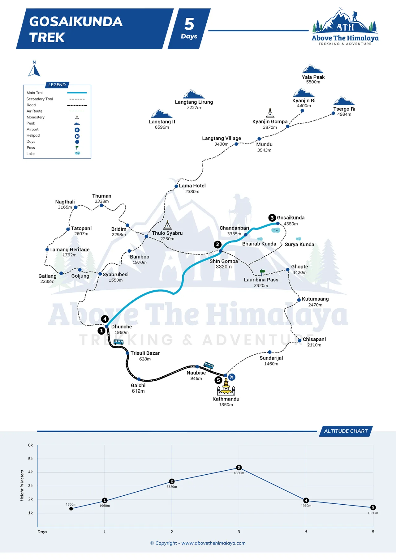
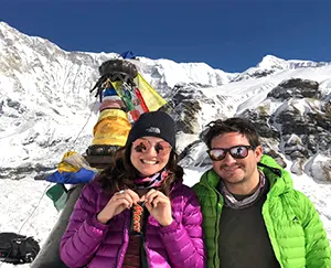
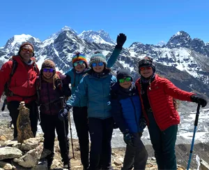
Your Trek Leader
 Enjoy Himalayan scenery with the help of Nepal’s best guides with Government license holders and got training in first-aid, our Trip Leaders, know where you’ll find the best photos, most fascinating wildlife, and the best stream crossings.
US$ 630 Per Person
Have Questions?Talk to Expert
Meet Mr. Purushotam Timalsena (Puru), Nepal's best trek and tour organizer, who has been working in the Himalayas for more than 24 years.
WhatsApp/Viber +977 98510 95 800


You May Like


Trips for All
Private Trip
Peaceful tour with your travel buddy and guide
Small Group Travel
Travel with people having similar adventure dreams
Trips for Kids
Calling all young adventurers - join us for a journey of a lifetime!
Trips for Adventurers
Climbing & mountaineering adventures for thrill-seekers


